Guangming Wang²*, Yu Zheng¹*, Yuxuan Wu¹, Yanfeng Guo⁴, Zhe Liu¹, Yixiang Zhu⁵, Wolfram Burgard³, Hesheng Wang¹†
² University of Cambridge, ¹ Shanghai Jiao Tong University, ³ University of Technology Nuremberg, ⁴ University of California, ⁵ Nanyang Technological University
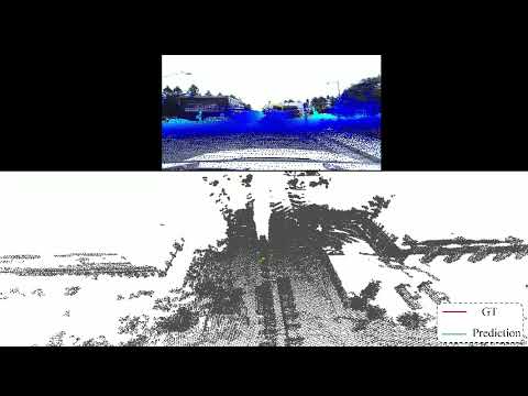
Robot localization using a built map is essential for a variety of tasks including accurate navigation and mobile manipulation. A popular approach to robot localization is based on image-to-point cloud registration, which combines illumination-invariant LiDAR-based mapping with economical image-based localization. However, the recent works for image-to-point cloud registration either divide the registration into separate modules or project the point cloud to the depth image to register the RGB and depth images. n this paper, we present I2PNet, a novel end-to-end 2D-3D registration network, which directly registers the raw 3D point cloud with the 2D RGB image using differential modules with a united target. The 2D-3D cost volume module for differential 2D-3D association is proposed to bridge feature extraction and pose regression. The soft point-to-pixel correspondence is implicitly constructed on the intrinsic-independent normalized plane in the 2D-3D cost volume module. Moreover, we introduce an outlier mask prediction module to filter the outliers in the 2D-3D association before pose regression. Furthermore, we propose the coarse-to-fine 2D-3D registration architecture to increase localization accuracy. Extensive localization experiments are conducted on the KITTI, nuScenes, M2DGR, Argoverse, Waymo, and Lyft5 datasets. The results demonstrate that I2PNet outperforms the state-of-the-art by a large margin and has a higher efficiency than the previous works. Moreover, we extend the application of I2PNet to the camera-LiDAR online calibration and demonstrate that I2PNet outperforms recent approaches on the online calibration task.
install required packages
pip install -r requirements.txtinstall pointnet2
cd pointnet2
python setup.py install
cd ../
install projection-aware operators
cd src/projectPN/fused_conv_select
python setup.py install
cd ../../../Download KITTI Odometry sequences and put the downloaded data in /dataset/data_odometry_velodyne and /dataset/data_odometry_color. The data should include the and Process the data sequentially as follows:
-
For large-range localization, you are recommended to use the output path
/dataset/data_odometry_velodyne_deepi2p_new:- For the calibration files, download the data_odometry_calib and put
data_odometry_calibin/dataset/data_odometry_velodyne_deepi2p_new. - For the point cloud:
If using the recommended path, the output will be put in
cd ./data_preprocess
python kitti_pc_bin_to_npy_with_downsample_sn.py --src $your_kitti_data_path$ --dst $your_output_path$
cd ../
/dataset/data_odometry_velodyne_deepi2p_new/data_odometry_velodyne_NWU/sequences/**/snr0.6/*.npy. - For the image:
If using the recommended path, the output will be put in
cd ./data_preprocess
python kitti_png_to_npy.py --src $your_kitti_data_path$ --dst $your_output_path$
cd ../
/dataset/data_odometry_velodyne_deepi2p_new/data_odometry_color_npy/sequences/**/image_2/*.npy. - For the poses:
If using the recommended path, the output will be put in
cd ./data_preprocess
python kitti_pose.py --src $your_kitti_data_path$ --dst $your_output_path$
cd ../
/dataset/data_odometry_velodyne_deepi2p_new/poses/**/*.npy. - Besides, since we also use
/dataset/kitti_processed_DeepI2Pin our dataloader, you should also create a symbol linkIf you use another output path, you should modify the path in this command.ln -s /dataset/data_odometry_velodyne_deepi2p_new/ /dataset/kitti_processed_DeepI2P
- For the calibration files, download the data_odometry_calib and put
-
For small-range localization, just run
cd ./data_preprocess/CMRNet_script
python kitti_maps_cmr.py --sequence 00 --kitti_folder ./KITTI_ODOMETRY/
cd ../
Note: please uncomment the range constraint at “# y \in [-10,10] x \in [-5,15]” in the kitti_maps_cmr.py code, and comment out lines at “# y \in [-25,25] x \in [-10,100]”
Download NuScenes Full dataset (v1.0) Dataset.
For large range localization, please download our filtered data list here, and put them under the nuScenes_datasplit folder.
For small range localization, process the data sequentially as follows:
python gen_maps_our.py \
    --voxel_size 0.1 \
    --nus_folder /dataset/nuScenes \
    --output_folder /dataset/nus_processed_CMRNet \
    --frame_skip 2 \
--max_translation 5- Training
python train20v2learn_wandb_proj.py --gpu 3 --dataset kd_corr_nolidar --modelcfg config_proj_lidarcenter --network modellearn_proj_center --log_dir <LOG> --max_epoch 200 --debug --clip 10- Evaluation
python evaluation_proj.py --dataset kd_corr_nolidar --modelcfg config_proj_lidarcenter --network modellearn_proj_center --log_dir <LOG>For evaluation with multiple iterations (currently set to 6 iters):
python evaluation_proj.py --dataset kd_corr_nolidar --modelcfg config_proj_lidarcenter_iter --network modellearn_proj_center_iter --log_dir <LOG>- Training
python train20v2learn_wandb_proj.py --gpu 3 --dataset nus_corr_nolidar --modelcfg config_proj_lidarcenter_nus --network modellearn_proj_center --log_dir <LOG> --max_epoch 200 --debug --clip 10- Evaluation
python evaluation_proj.py --dataset nus_corr_nolidar --modelcfg config_proj_lidarcenter_nus --network modellearn_proj_center --log_dir <LOG>python evaluation_analysis.py --log_dir <LOG> --target <metrics_name_in_'info_test'>For cross dataset evaluation, you could simply change the dataset and modelcfg args to the according dataset. For example, for evaluation from KITTI Odometry to NuScenes dataset, run:
python evaluation_proj.py --dataset nus_corr_nolidar --modelcfg config_proj_lidarcenter_nus --network modellearn_proj_center --log_dir <Your_KITTI_training_LOG_dir>- Training
python train20v2learn_wandb.py --gpu 1 --dataset kd_cmr_snr --modelcfg config_lidarcenter --log_dir <LOG> --debug --clip 10- Evaluation
python evaluation_cmr.py --dataset kd_cmr_snr --log_dir <LOG> --gpu 1- Training
python train20v2learn_wandb.py --gpu 2 --dataset nus_cmr_snr --modelcfg config_lidarcenter --log_dir <LOG> --debug --clip 10- Evaluation
python evaluation_cmr.py --dataset nus_cmr_snr --log_dir <LOG> --gpu 1python evaluation_cmrresult.py --log_dir <LOG>@ARTICLE{wang2023end,
author={Wang, Guangming and Zheng, Yu and Wu, Yuxuan and Guo, Yanfeng and Liu, Zhe and Zhu, Yixiang and Burgard, Wolfram and Wang, Hesheng},
journal={IEEE Transactions on Robotics},
title={End-to-End 2D-3D Registration Between Image and LiDAR Point Cloud for Vehicle Localization},
year={2025},
volume={41},
number={},
pages={4643-4662},
doi={10.1109/TRO.2025.3588454}
}
- Implementation of PointNet++ is based on Pointnet2_PyTorch.
- Implementation of data preprocessing inherited from CMRNet.
- Implementation of projection-aware operators from EfficientLO-Net.